Whether calculating routes, finding your vehicle, tracking products or simply knowing where you are at the moment, drivers and sailors currently use satellite navigation as a matter of course and rescue personnel and logistics providers have also already discovered the potential it affords them. Up to now, the applications have mainly been based on the direction signals of the military's publicly available Global Positioning Systems (GPS). When the first four of a total of 30 satellites of the European Global Navigation Satellite System (GNSS) Galileo will be put into service in 2012, civilian users will be the main beneficiaries. "For them, the satellite navigation system will improve successively on all levels," remarked Wolfgang Inninger of the Fraunhofer Institute for Material Flow and Logistics IML in Prien. Positioning via satellite will become more reliable, more precise and safer. For one thing, the user will be able to access more satellites. Galileo will also offer a function for various services that makes it possible to check the correctness of the transmitted position data. This function makes it possible, for example, to carry out environmental impact measurements within flowing traffic. Data from these measurements can be used by the authorities only if they are "legally sound," meaning if each measurement value can be clearly attributed to a measurement site. Current GPS positioning does not provide this.
The Fraunhofer Gesellschaft's five Galileo Labs, at their sites in Berlin, Dortmund, Dresden, Erlangen and Prien respectively, demonstrate how the new possibilities of the GNSS can be used. A mobile environmental monitoring system for measuring pollutant gases and fine dust is currently being developed in the Berlin lab at the Fraunhofer Institute for Production Systems and Design Technology IPK, in cooperation with the Fraunhofer Institute for Physical Measurement Techniques IPM in Freiburg. It is intended to supplement the knowledge gained from the stationary environmental measurements with real-time traffic data. At the beginning of last year, scientists from the IML Prien and local rescue personnel successfully tested a Galileo-supported positioning system for the victims of avalanches at the Galileo test and development area (GATE) in Berchtesgaden. Eight pseudo-satellites on top of eight mountain tops emit Galileo signals during the application tests. "During this field test we located the 'avalanche victims' by within a few centimeters," reports Inninger. He estimates that the location precision could double for all GNSS applications due to the fact that there will be more satellites available. In the future, most end-user devices will be able to utilize both GPS and Galileo signals, some devices in conjunction with additional localization methods. Scientists of the Fraunhofer Institute for Integrated Circuits IIS at the Galileo lab in Erlangen are working on a combination of positioning from Galileo and WLAN signals within a building, for example, to make it easier for fire fighters to orient themselves in burning buildings. In the future, the same principle could be used to simplify the management of warehouses in commerce or in manufacturing enterprises. Logisticians at the Galileo lab in Dortmund are developing a system that fully and automatically monitors palettes by means of satellite positioning – both within and outside the warehouse.

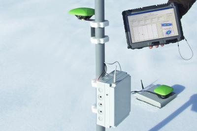
Galileo's receiving technology distinguished itself through its very high precision. For example, the system makes it possible to detect the precise location of avalanche victims.
(Photo Credit: Fraunhofer IML)
Source: Fraunhofer-Gesellschaft