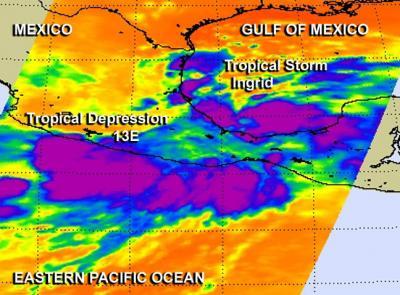
Friday the thirteenth is known for being unlucky and residents along Mexico's eastern and western coast are experiencing that feeling as a result of newborn Tropical Depression 13E in the eastern Pacific Ocean, and newborn Tropical Storm Ingrid in the Gulf of Mexico. Both storms formed during the morning of Sept. 13. Both storms were captured on one infrared imagery from NASA's Aqua satellite, and both storms have the potential to drop as much as 20 inches of rain.
The Atmospheric Infrared Sounder instrument called AIRS that flies aboard NASA's Aqua satellite captured an infrared image of developing Tropical Depression 13E (TD13E) and Tropical Storm Ingrid on Sept. 13 at 1:23 UTC (9:23 p.m. EDT, Sept. 13). Both TD13E and Ingrid were classified as such on Sept. 13 at 11 a.m. EDT. TD13E formed along the western coast of Mexico, while Ingrid formed on the east coast in the Bay of Campeche. The AIRS image showed powerful storms and cold cloud top temperatures colder than -63F/-52C over a large area in TD13, and in a more concentrated, circular area within Tropical Storm Ingrid.
At 11 a.m. EDT, Tropical Depression 13E had maximum sustained winds near 35 mph/55 kph. It was centered near 15.7 north and 101.3 west, about 140 miles/225 km south of Zihuatanejo, Mexico, and about 170 miles/275 km south-southeast of Lazaro Cardenas, Mexico. TD13E was moving to the northwest at 3 mph/6 kph.

Aqua captured an infrared image of developing Tropical Depression 13E and Tropical Storm Ingrid on Sept. 13. TD13E formed along the western coast of Mexico, while Ingrid formed on the east coast. This image shows powerful storms and cold cloud top temperatures colder than -63F/-52C in purple.
(Photo Credit: NASA JPL/Ed Olsen)
Like Tropical Storm Ingrid on the eastern side of Mexico, that is also slowly moving north, Tropical Depression 13E is expected to drop a lot of rain. The government of Mexico has issued a tropical storm warning for the southwest coast of Mexico from Acapulco to Lazaro Cardenas. On the forecast track, the National Hurricane Center noted that the depression should bBe very near the coast of southwestern Mexico within the warning area by late Saturday, Sept. 14.
Rainfall is going to be the biggest threat, with expectations of between 10 to 15 inches of rain over portions of the Mexican states of Oaxaca and Guerrero. Some areas may see isolated maximum amounts of 20 inches possible. These rains are likely to result in life-threatening flash floods and mudslides, especially in mountainous areas.
Source: NASA/Goddard Space Flight Center