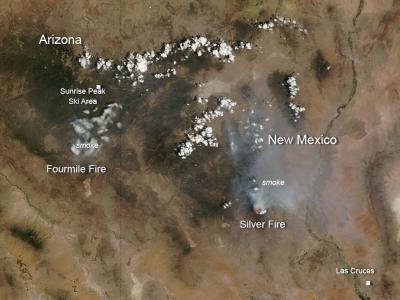
The Fourmile fire located 20 miles northeast of Morenci, Arizona is basically a grass fire. Currently it is over 5000 acres in size and is not contained at all. Because of the hot, dry conditions, the potential for growth of this fire is high. Officials are estimating that containment of this fire will be on or about June 15, 2013.
Silver Fire in New Mexico was started on June 7 by a lightning strike about 7 miles southwest of Kingston, NM. Currently this fire is 6,700 acres in size and its potential for growth is high. Firefighters are challenged by extremely rough terrain, a substantial amount of unburned fuel and beetle-killed trees, and extreme fire conditions. Firefighters are working on point protection around structures, roads and area campgrounds.
An evacuation order was issued for Kingston Monday morning at 1:40 a.m., after the fire crossed a pre-established trigger point about 2.5 miles from Kingston. That order remains in place.
The Fourmile fire located 20 miles northeast of Morenci, Ariz., is basically a grass fire. Currently it is over 5,000 acres in size and is not contained at all. Because of the hot, dry conditions, the potential for growth of this fire is high. Officials are estimating that containment of this fire will be on or about June 15, 2013.
Silver Fire in New Mexico was started on June 7 by a lightning strike about 7 miles southwest of Kingston, N.M. Currently this fire is 6,700 acres in size and its potential for growth is high. Firefighters are challenged by extremely rough terrain, a substantial amount of unburned fuel and beetle-killed trees, and extreme fire conditions. Firefighters are working on point protection around structures, roads and area campgrounds.
An evacuation order was issued for Kingston Monday morning at 1:40 a.m., after the fire crossed a pre-established trigger point about 2.5 miles from Kingston. That order remains in place.
This natural-color satellite image was collected by the Moderate Resolution Imaging Spectroradiometer (MODIS) aboard the Terra satellite on June 10, 2013. Actively burning areas, detected by MODIS's thermal bands, are outlined in red.
(Photo Credit: NASA image courtesy Jeff Schmaltz, MODIS Rapid Response Team. Caption: NASA/Goddard, Lynn Jenner)
This natural-color satellite image was collected by the Moderate Resolution Imaging Spectroradiometer (MODIS) aboard the Terra satellite on June 10, 2013. Actively burning areas, detected by MODIS's thermal bands, are outlined in red.
Source: NASA/Goddard Space Flight Center