Fires in and around Snowy River National Park in Victoria, Australia were captured by the Moderate Resolution Imaging Spectroradiometer (MODIS) aboard the Aqua satellite on February 06, 2014. Actively burning areas, detected by MODIS's thermal bands, are outlined in red.
Hot, dry, windy conditions in Victoria have been responsible for the rash of bushfires breaking out across the territory. The fires in this image are located in and around the Snowy River National Park, specifically in the Yalmy and Deddick Valley area. Both bushfires are not under control at this time although authorities are on the scene. In Deddick Valley seventeen vehicles are currently attending the 15,000+ acre fire. In Yalmy (Vic Emergency map) almost 27,000 acres are burning.
Authorities are warning residents to gear up for another round of hot, dry weather this coming weekend that could start new rounds of fires in the area. (ABC News in Australia)
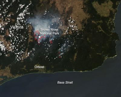
Fires in and around Snowy River National Park in Victoria, Australia, were captured by the Moderate Resolution Imaging Spectroradiometer aboard the Aqua satellite on Feb. 6, 2014. Actively burning areas, detected by Moderate Resolution Imaging Spectroradiometer's thermal bands, are outlined in red.
(Photo Credit: NASA image courtesy Jeff Schmaltz, MODIS Rapid Response Team. Caption: NASA/Goddard, Lynn Jenner)
Source: NASA/Goddard Space Flight Center