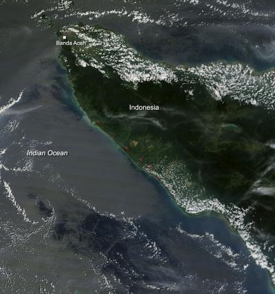
Fires dot the coast of Northern Sumatra, Indonesia, in this Moderate Resolution Imaging Spectroradiometer (MODIS) satellite image collected on February 06, 2014. The MODIS instrument is aboard the Terra satellite and actively burning areas, detected by MODIS's thermal bands, are outlined in red.
Slash and burn agriculture is banned in Indonesia, but that does not always stop the farmers from using it to clear fields. An unusual dry spell in the area (this is usually the rainy season through March) has given farmers the window of opportunity to use this time to clear fields with the slash and burn method. The Asia News Network reported that "'Farmers [in Riau] used the two weeks without rain to carry out slash- and-burn,' Tri Budiarto, the National Disaster Management Agency's deputy for emergency management, said in Jakarta on Wednesday." The Jakarta Post reported that, apart from forests and farms, seven hot spots were spotted in oil palm plantations and forest concessions.
It is not confirmed that the fires seen in this satellite image are connected to the slash and burn agriculture method, but it does seem likely given the history in that area.
(Photo Credit: NASA image courtesy Jeff Schmaltz, MODIS Rapid Response Team. Caption: NASA/Goddard, Lynn Jenner)
It is not confirmed that the fires seen in this satellite image are connected to the slash and burn agriculture method, but it does seem likely given the history in that area.
Source: NASA/Goddard Space Flight Center