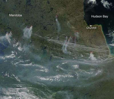
There are currently 27 fires in the northeast section of Manitoba. These fires have burned over 126,000 hectares (over 311,000 acres). Showers have lowered wildfire danger levels in most areas of the province with the exception of northeastern Manitoba where conditions continue to remain dry. The hot temperatures forecasted through this coming weekend will dry forested areas and increase these danger levels. The fire weather forecast for this area is for fast-spreading, high-intensity crown fire that is very difficult to control.
This natural-color satellite image was collected by the Moderate Resolution Imaging Spectroradiometer (MODIS) aboard the Terra satellite on June 29, 2013. Actively burning areas, detected by MODIS's thermal bands, are outlined in red.
(Photo Credit: NASA image courtesy Jeff Schmaltz, MODIS Rapid Response Team. Caption: NASA/Goddard, Lynn Jenner)
Source: NASA/Goddard Space Flight Center