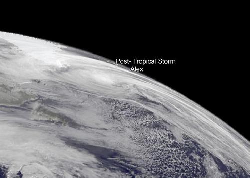
Tropical Storm Alex quickly acquired extra-tropical characteristics late on Jan. 15, 2016 as it sped northward toward Greenland in the North Atlantic Ocean. A GOES-East satellite image on Jan. 16 showed the elongated system south of Greenland.
Tropical Storm Alex became extra-tropical by Jan. 15, 2016 at 2100 UTC (4 p.m. EST). At that time the National Hurricane Center issued their final warning on the system and said "Satellite images and surface observations indicate that Alex has lost its tropical characteristics."
Alex was located near 43.0 degrees north latitude and 27.8 degrees west longitude, about 290 miles (470 km) north of Terceira, Azores. Alex's maximum sustained winds had dropped to 35 knots (40 mph/62 kph). Alex was speeding to the north at 35 knots (40 mph/62 kph) and had a minimum central pressure of 986 millibars.
 On Sat. Jan. 16, 2016, NOAA's GOES-East satellite captured a visible image of Post-Tropical Storm Alex showing that the storm's cloud pattern became elongated and now resemble a frontal shape. Credit: Credits: NASA/NOAA GOES Project
A scatterometer pass on Jan. 15 showed that the system was losing its inner-core wind maximum, with the strongest winds well-removed to the northeast of the center.
On Saturday, Jan. 16, 2016 NOAA's GOES-East satellite captured a visible image of extra-tropical storm Alex. Both GOES and low-level microwave satellite images showed that Alex's cloud pattern became elongated and now resemble a frontal shape.
NHC expects Alex to be just south of Greenland today, Jan. 16, 2016 at 1800 UTC (1 p.m. EST) near 56.3 degrees north latitude and 36.1 degrees west longitude. Maximum sustained winds increased to 75 mph but are expected to weaken quickly. By Jan. 17, 2016 at 1800 UTC (1 p.m. EST), Alex is expected be absorbed into another extra-tropical low pressure area.
source: NASA/Goddard Space Flight Center