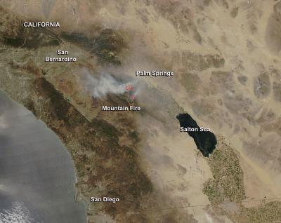
NASA's Aqua satellite captured an image of California's Mountain Fire on July 18 as the satellite passed overhead in space.
The Moderate Resolution Imaging Spectroradiometer (MODIS) instrument that flies aboard Aqua captured an image of the smoke and heat from California's Mountain Fire on July 18 at 21:00 UTC (5 p.m. EDT/2 p.m. PDT). MODIS has the ability to detect hot spots or fires and they appear red in the image. At the time of the image, the light brown smoke plume was blowing west-northwest.
The Mountain Fire started on July 15 at 1:43 p.m. near the junction of Highway 243 and Highway 74. The topography of the burning area is very steep and rugged. The fire is located in the southern portion of the San Jacinto Wilderness along the Desert Divide.
The Incident Information System called InciWeb noted that evacuations have been ordered. There are evacuations for the Idyllwild and Fern Valley area (not including Pine Cove, Mountain Center, and Poppet Flats). Evacuations also include the San Jacinto State Park Wilderness, Forest Service Wilderness and Forest Service Campgrounds. As of July 18, 22,800 acres have burned and the fire was reported at 15 percent containment. For more updates on this fire, visit the InciWeb page: http://www.inciweb.org/incident/3516/.
(Photo Credit: Image: Jeff Schmaltz, NASA Goddard MODIS Rapid Response Team; Caption: Rob Gutro, NASA Goddard Space Flight Center)
The Incident Information System called InciWeb noted that evacuations have been ordered. There are evacuations for the Idyllwild and Fern Valley area (not including Pine Cove, Mountain Center, and Poppet Flats). Evacuations also include the San Jacinto State Park Wilderness, Forest Service Wilderness and Forest Service Campgrounds. As of July 18, 22,800 acres have burned and the fire was reported at 15 percent containment. For more updates on this fire, visit the InciWeb page: http://www.inciweb.org/incident/3516/.
Source: NASA/Goddard Space Flight Center