California's King Fire tripled in size from Monday, September 15 to Tuesday morning, September 16, and current weather conditions are doing nothing more than helping it along. The hot, drought conditions and winds have produced over 12 major fires that still burn all over California. The King Fire is just one of them. It is located east of Sacramento in the Pollock Pines community. Residents have been given mandatory evacuation orders and over 1,600 homes are currently threatened by this fire. It began Saturday September 13 and has spread rapidly through the area fueling itself with heavy timber and undergrowth. The fire is expected to spread to the east, north and west with the fire well-established in several canyon bottoms burning uphill to the ridges above. The cause of the fire remains under investigation. It is currently 5% contained.
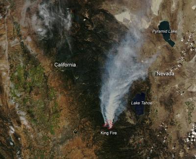
This natural-color satellite image was collected by the Moderate Resolution Imaging Spectroradiometer (MODIS) aboard the Aqua satellite on Sept. 16, 2014. Actively burning areas, detected by MODIS's thermal bands, are outlined in red.
(Photo Credit: NASA image courtesy Jeff Schmaltz, MODIS Rapid Response Team. Caption: NASA/Goddard, Lynn Jenner with information from Inciweb)
Source: NASA/Goddard Space Flight Center