In Syria's largest city, Aleppo, damage to buildings and infrastructure steadily increased over a ten-month period ending in May 2013, according to a new analysis of images taken by satellites. Virtually all of the destruction appears to be in rebel-controlled or contested areas, and a substantial amount is in Aleppo's Ancient City, a UNESCO World Heritage Site.
Aleppo has been the site of ongoing conflict since July 2012. Since then, the city has experienced a nearly constant rate of damage to its physical structures, at about three incidents per day on average, according to the report, which was commissioned by Amnesty International and conducted by the AAAS Geospatial Technologies and Human Rights Project advocacy group. The authors looking at the pictures also documented other signs of intensifying military activity, such as an increased deployment of military equipment and a proliferation of improvised roadblocks.
The analysis compares nine satellite images collected at regular intervals between August 2012 and May 2013.
"We are documenting a war zone," said Susan Wolfinbarger, Director of the Geospatial Technologies and Human Rights Project, about their looking at pictures taken by machines thousands of miles away. "It's a really dangerous situation in Aleppo. There are people on the ground reporting out, but they're in specific, localized places and not able to move around freely. What we're able to do is provide a comprehensive look at the situation over time, examining the entire city and assessing what is going on throughout the area."
In addition to the battered buildings and other structures that appear in the satellite images, debris fields and craters also indicate damage.
The destruction has not been uniform, the pictures showed, apparently surprised that war is not linear. Some areas have been heavily affected by the conflict, while others remain largely or totally unaffected. Of the 713 incidents of destruction observed during the study period, only six took place in districts reported to be under the control of forces loyal to the Syrian government. The rest were in areas under rebel control, under Kurdish control — whose authority was actively being contested — or for which control was unknown.
Located at the crossroads of trade routes that date back to the second millennium B.C., Aleppo contains many ancient structures of historical and cultural significance. The report documents damage to at least ten multi-story buildings as well as to mosques and cemeteries in the Ancient City. It also corroborates previous reports of damage to two important historical sites, the Umayyad Mosque and the Souq al-Madina.
The results also show an increase in military equipment, including artillery, tanks and aircraft in the affected areas. A number of military helicopters, for example, were observed on the tarmac at the Aleppo International Airport. Their numbers and positions changed frequently, suggesting regular use.
"Though other interpretations may be possible, this striking dichotomy in damage, in conjunction with direct observations of military activity, is consistent with reports that government forces have been using aircraft, missiles, and long-range artillery to bombard rebel-held areas," the report stated.
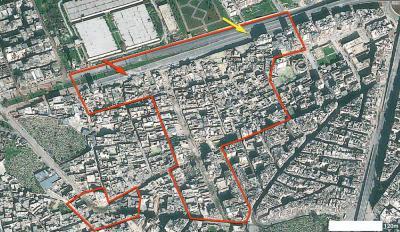
This is an example of massive destruction. On 9 September 2012 (top) Aleppo's Karm al-Jabal district is completely intact. By 15 December 2012, however, large areas of the district (outlined in red) have suffered extensive damage, one large multistory tower (red arrows) has been destroyed, and another (yellow arrows) has partially collapsed. Roadblocks and debris in the street suggest heavy fighting. Imagery copyright 2013 DigitalGlobe
The creation of roadblocks to control movement within the city has also ramped up in the past year, as documented in the report. These appear to be mostly trucks or buses placed across strategic intersections, but others take the form of earthen barricades or deep trenches.
"It's interesting to see that the roadblocks are all across the city. One might think these would be more prevalent in rebel-held areas – perhaps as defensive positions – but in fact, it appears that the highest concentrations occur where regime forces are reported to be in control," said Jonathan Drake, an imagery analyst for the Project.
The image analysis covered 182 square kilometers of Aleppo and surrounding regions. It was based on nine satellite images captured over a ten-month period by DigitalGlobe Inc.'s Quickbird-2, Ikonos-2, and Geoeye-1 satellites, as well as by Astrium's Pleiades satellite. A previous lookreport at the same area, based on two images captured in August 2012, appeared to reveal the deployment of heavy armored vehicles in civilian neighborhoods as well as 117 instances of damage to buildings and infrastructure.
The AAAS Geospatial Technologies and Human Rights Project, part of the association's Scientific Responsibility, Human Rights and Law Program, has previously provided image analysis to promote action in Afghanistan, Nigeria, South Ossetia, Turkmenistan, Zimbabwe and many other regions.
The Project was recently awarded a $119,474 grant from the United States Institute of Peace (USIP) that will enable AAAS to analyze cross-border conflicts using satellite imagery and to identify trends for the future use of this technology as a means of conflict early-warning prediction and prevention.
On 25 July, the United Nations announced that the civil war in Syria had taken more than 100,000 lives since it began in 2011. The United States is providing nearly $510 million in humanitarian aid in response to the Syrian crisis and Congress has recently approved a proposal by President Obama to begin putting even more weapons in the area, this time for military support to the Syrian rebels. The United Nations plans to send inspectors to Syria to investigate three reports of chemical weapons use - the same AAAS said never happened against Kurds in Iraq when German and British intelligence said they did.
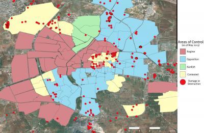
The spatial distribution of destruction in Aleppo is severely lopsided with respect to political control. Of the 713 instances that were observed during the study period, only six occurred in areas reported to be occupied by regime forces. Neighborhood control data courtesy USAID; Imagery copyright 2013 DigitalGlobe; Analysis by AAAS