The results from both instruments made sense if these radar-bright regions (also the altimeter's dark regions) represented water ice covered by a layer of other material. The much rarer bright regions seen by the altimeter would then indicate ice exposed on the surface.
Computer modeling by David Paige of the University of California, Los Angeles, and colleagues showed that Mercury's average temperatures in these areas are low enough for ice to be stable over time. A blanket of insulating material is needed to maintain ice in the altimeter's dark regions, but other spots receive so little sunlight that ice could persist right on the surface.
The ice seems to be the result of a geologically recent or ongoing process, perhaps delivered by comets and other small bodies from the outer solar system. Organic chemicals from those same bodies might make up the material that covers the ice in most places. More work needs to be done before these follow-on questions can be answered definitively.
"But these new findings let us discard the proposals that the radar might be picking up other reflective materials instead of ice," says Neumann. "Now we can focus on understanding the processes that are emplacing volatiles at Mercury's poles."

MESSENGER's Mercury Laser Altimeter sends out laser pulses that hit the ground and return to the instrument. The amount of light that returns for each pulse gives the reflectance at that point on the surface. The amount of time it takes the pulse to make its trip indicates how far away that point on the surface is, allowing the topography to be mapped.
(Photo Credit: NASA/Goddard Space Flight Center)
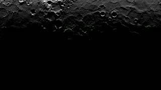
Parts of Prokofiev crater (center) and Kandinsky crater (upper left side of Prokofiev) stay in darkness, making it possible for ice to persist on the surface. This time-lapsed animation represents nearly a full Mercury day. The illumination is derived from information provided by the Mercury Laser Altimeter.
(Photo Credit: NASA)
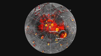
Shown in red are areas of Mercury's north polar region that are in shadow in all images acquired by MESSENGER to date. The polar deposits imaged by Earth-based radar are in yellow. This comparison indicates that all of the polar deposits imaged by Earth-based radar are located in areas of persistent shadow as documented by MESSENGER images.
(Photo Credit: NASA/Johns Hopkins University Applied Physics Laboratory/Carnegie Institution of Washington/National Astronomy and Ionosphere Center, Arecibo Observatory. Updated from N. L. Chabot et al., Journal of Geophysical Research, 117, doi: 10.1029/2012JE004172 (2012).)
Source: NASA/Goddard Space Flight Center