NASA's Terra Satellite, the GOES-13 and GOES-11 satellites all captured images of the ash plume from southern Chile's Puyehue-Cordón Volcano this week. The volcano is located in Puyehue National Park in the Andes of Ranco Province of Chile.
The Terra satellite flew over the volcano on June 6 at 14:25 UTC (10:25 a.m. EDT). The Moderate Resolution Imaging Spectroradiometer (MODIS) instrument captured a visible image of the eruption that showed the large ash plume blowing northeast, then to the southeast and over the Atlantic Ocean. The ash plume went at least as high as six miles on June 4 when it erupted, according to CNN International. Some 3,500 people were evacuated.
The Geostationary Operational Environmental Satellites called GOES-13 and GOES-11 also captured images of the volcano
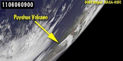
GOES-11 satellite image, taken on June 6 at 0900 UTC (5 a.m. EDT) from the farthest vantage point of any of the satellites, still showed the triangular-shaped plume, even from its position over the western US, despite the large distance.
(Photo Credit: NASA/NOAA GOES Project, Dennis Chesters)
from a different vantage point in space that revealed the plume was visible from even farther away.
GOES-13 monitors the eastern U.S. and the Atlantic Ocean, while GOES-11 monitors the western U.S. and eastern Pacific Ocean. The GOES-11 satellite image, taken from the farthest vantage point of any of the satellites, still showed the triangular-shaped plume, even from its position over the western U.S., despite the large distance.
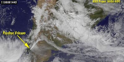
This image of the eruption of the Puyehue-Cordón Caulle volcano (left center), Chile was captured by the GOES-13 Satellite on June 6 at 14:45 UTC (10:45 a.m. EDT). The plume is blowing northeast, then turns toward the southeast and over the Atlantic Ocean.
(Photo Credit: NASA/NOAA GOES Project, Dennis Chesters)
Source: NASA/Goddard Space Flight Center