NASA's Aqua satellite passed over Hurricane Humberto and analyzed the storm in infrared light using the Atmospheric Infrared Sounder known as AIRS and visible light using the MODIS instrument. AIRS gathered data on Sept. 11 at 03:29 UTC/Sept. 10 at 11:29 p.m. EDT and revealed cloud cloud-top temperatures in excess of -63F/-52C in thunderstorms around the hurricane's center of circulation and in bands of thunderstorms west of the center. The MODIS or Moderate Resolution Imaging Spectroradiometer instrument showed a thick band of thunderstorms wrapping into the center from the west.
At 11 a.m. EDT on Sept. 11, Hurricane Humberto made a turn to the north and is expected to continue in that direction for another day or two. It was centered about 340 miles/550 km west of the Cape Verde Islands, near 16.7 north and 29.1 west. Humberto has maximum sustained winds near 80 mph/130 kph and is moving to the north near 9 mph/15 kph.
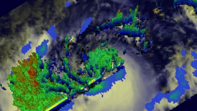
In this satellite flyby animation, NASA's TRMM satellite passed over Humberto on Sept. 10 and measured rainfall rates of up to 2 inches/50 mm per hour (red) in the large band of thunderstorms west of Humberto's center.
(Photo Credit: SSAI/NASA, Hal Pierce)
The National Hurricane Center noted that Humberto could strengthen a little today before weakening on Sept. 12. Humberto is headed for cooler waters and an environment where wind shear is expected to increase which is why it is expected to weaken.
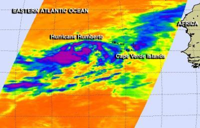
NASA's Aqua satellite passed over Hurricane Humberto on Sept. 10 at 11:29 p.m. EDT and revealed cloud cloud-top temperatures in excess of -63F/-52C (purple) in thunderstorms around the hurricane's center of circulation and in bands of thunderstorms west of the center.
(Photo Credit: NASA JPL, Ed Olsen)
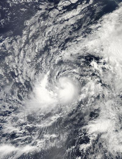
The MODIS instrument aboard Aqua captured this visible image of Humberto when it was a tropical storm on Sept. 10 at 11:20 a.m. EDT. The Cape Verde Islands are seen to the right of Humberto and a strong band of thunderstorms were wrapping into the center from the storm's west.
(Photo Credit: NASA)
Source: NASA/Goddard Space Flight Center