WASHINGTON -- The average area covered by the Antarctic ozone holethis year was the second smallest in the last 20 years, according todata from NASA and National Oceanic and Atmospheric Administration(NOAA) satellites. Scientists attribute the change to warmertemperatures in the Antarctic lower stratosphere.
The ozone hole reached its maximum size Sept. 22, covering 8.2 millionsquare miles (21.2 million square kilometers), or the area of theUnited States, Canada and Mexico combined. The average size of the2012 ozone hole was 6.9 million square miles (17.9 million squarekilometers). The Sept. 6, 2000 ozone hole was the largest on recordat 11.5 million square miles (29.9 million square kilometers).
"The ozone hole mainly is caused by chlorine from human-producedchemicals, and these chlorine levels are still sizable in theAntarctic stratosphere," said NASA atmospheric scientist Paul Newmanof NASA's Goddard Space Flight Center in Greenbelt, Md. "Naturalfluctuations in weather patterns resulted in warmer stratospherictemperatures this year. These temperatures led to a smaller ozonehole."
The ozone layer acts as Earth's natural shield against ultravioletradiation, which can cause skin cancer. The ozone hole phenomenonbegan making a yearly appearance in the early 1980s. The Antarcticozone layer likely will not return to its early 1980s state untilabout 2065, Newman said. The lengthy recovery is because of the longlifetimes of ozone-depleting substances in the atmosphere. Overallatmospheric ozone no longer is declining as concentrations ofozone-depleting substances decrease. The decrease is the result of aninternational agreement regulating the production of certainchemicals.
This year also showed a change in the concentration of ozone over theAntarctic. The minimum value of total ozone in the ozone hole was thesecond highest level in two decades. Total ozone, measured in Dobsonunits (DU), reached 124 DU on Oct. 1. NOAA ground-based measurementsat the South Pole recorded 136 DU on Oct. 5. When the ozone hole isnot present, total ozone typically ranges from 240-500 DU.
This is the first year growth of the ozone hole has been observed byan ozone-monitoring instrument on the Suomi National Polar-orbitingPartnership (NPP) satellite. The instrument, called the Ozone MappingProfiler Suite (OMPS), is based on previous instruments, such as theTotal Ozone Mapping Spectrometer (TOMS) and the Solar BackscatterUltraviolet instrument (SBUV/2), which have flown on multiplesatellites. OMPS continues a satellite record dating back to theearly 1970s.
In addition to observing the annual formation and extent of the ozonehole, scientists hope OMPS will help them better understand ozonedestruction in the middle and upper stratosphere with its NadirProfiler. Ozone variations in the lower stratosphere will be measuredwith its Limb Profiler.
"OMPS Limb looks sideways, and it can measure ozone as a function ofheight," said Pawan K. Bhartia, a NASA atmospheric physicist and OMPSLimb instrument lead. "This OMPS instrument allows us to more closelysee the vertical development of Antarctic ozone depletion in thelower stratosphere where the ozone hole occurs."

The ozone hole max is on Sept. 22, 2012.
(Photo Credit: NASA/Goddard Space Flight Center)
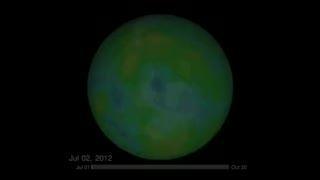
This video shows the status of the ozone hole between Jul. 1, 2012 to Oct. 19, 2012. The hole reached its maximum on Sept. 22, 2012.
(Photo Credit: NASA Goddard Space Flight Center/SVS)
Source: NASA/Goddard Space Flight Center