The Aqua satellite provided this satellite image showing a series of hotspots found in the Siberian region of Russia. These hotspots have been categorized as wildfires rather than agricultural fires by the website: http://fires.kosmosnimki.ru/ The popular Kosmosnimki.Ru web resource introduces the "hybrid" view option – map layers over satellite-based image. MODIS fire hotspots have been layered over the satellite image and provide clickable areas to see exactly how many hotspots are being detected and what type they are. Because we are getting into the hot, dry time of year in this area it is likely that these are wildfires.
This natural-color satellite image was collected by the Moderate Resolution Imaging Spectroradiometer (MODIS) aboard the Aqua satellite on May 10, 2013. Actively burning areas, detected by MODIS's thermal bands, are outlined in red.
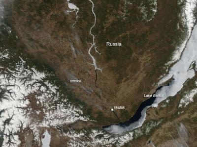
The Aqua satellite provided this satellite image showing a series of hotspots found in the Siberian region of Russia. This natural-color satellite image was collected by the Moderate Resolution Imaging Spectroradiometer aboard the Aqua satellite on May 10, 2013. Actively burning areas, detected by MODIS's thermal bands, are outlined in red.
(Photo Credit: NASA image courtesy Jeff Schmaltz LANCE/EOSDIS MODIS Rapid Response Team, GSFC. Caption by Lynn Jenner)
Source: NASA/Goddard Space Flight Center